I love maps and can spend hours dreaming about places to go next or thinking about where I’ve been. I also love GPS technology, and have had a handheld GPS in one form or another since the early days of the Garmin eTrex (circa 2000). It still amazes me that I can carry around a device that can show me exactly where I’m at on a map.
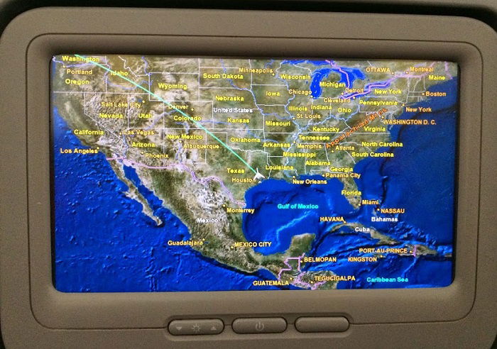
It probably comes as no surprise then that I’m a big fan of real-time flight maps while in the air. When I’m flying over parts of the world that I’m familiar with, I like to see if I can identify the features below, like cities, rivers, or mountains, especially ones that I’ve climbed. And when I’m in an unfamiliar part of the world, it’s nice to get a general idea about I’m looking at.
In fact, I’m so fascinated by maps and navigation that when I have an empty seat between my son and I — as I frequently do on international flights — I usually set the TV at the empty seat to the map channel so I can glance over at it while watching a movie on my screen.
But of course, not all planes have flight maps as part of their inflight entertainment system. For those cases, you need to bring your own.
Google Maps Probably Won’t Work
You might think that you could just use the mapping app on your smartphone while you’re flying to figure out where you are. The problem is that Google maps stores data in the cloud. It only downloads the relevant sections of the map that you need, when you need it. It’s essentially “just in time mapping.” That means that if you don’t have an internet connection, you’re pretty much hosed.
A friend of mine learned this the hard way when his party was using an iPhone to navigate while on a snowmobiling trip in remote Wyoming– they ended up outside the range of the nearest cell tower, got lost, and spent a cold night in the snow before luckily being rescued the next day.
If you don’t have an internet connection, this is pretty much what you get from Google Maps.
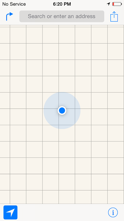
Gee thanks Google, that’s really helpful.
Maps.Me (MapsWithMe) Stores Maps Locally
The solution to this problem is use an app that downloads and stores the mapping data locally so that you can access it even when you don’t have a data connection. There are a variety of apps that will do this (and you might even be able to configure Google maps to operate this way), but I’ve been using Maps.Me for a couple of years with good results.
After installing the Maps.Me app, you download the maps for the parts of the world that you care about. You can do this at home, in the airport, or in the hotel, but the key is that you need to do it before you’re without a data connection. Then when you no longer have data available — or are too cheap to pay for it — you still have access to the maps.
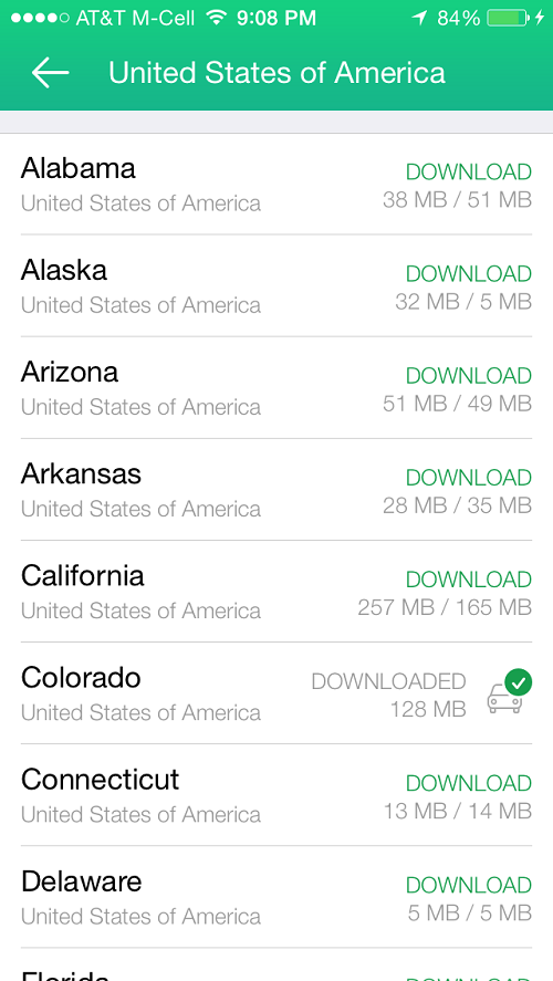
In theory, you can just download the maps as you need them, even over a cellular data connection. But since you’re probably using Maps.Me because you’re somewhere that none of your other cloud-based mapping apps are working, you really need to think about what you’ll need before you need it. Otherwise you’ll end up with just the basemap that comes as part of the standard Maps.Me installation. It’s better than nothing, but trust me, you’ll be mad at yourself for not planning ahead.
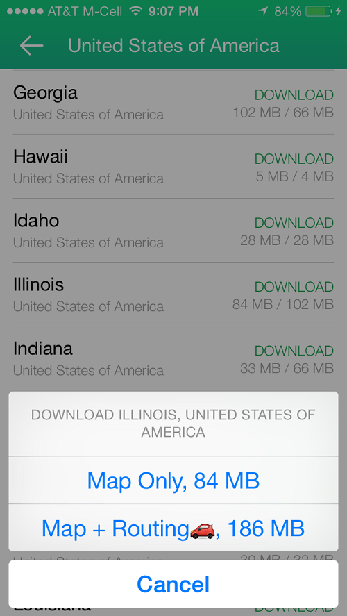
It’s also worth noting that when you download a map you have a choice between getting just the map or the map and the routing capability. The trade-off is in the size of the file that you need to download and then store on your phone — the routing capability takes up quite a bit of space. For in-air navigation, the routing capability is unnecessary.
My Experience Using Maps.Me
I’ve used Maps.Me not only in the air, but also in places like Burma where cellular data is hard to come by. (I still carry my Garmin Vista HCx handheld GPS with me to places like that, but it’s mostly just a backup.) For those without a good international data plan, using an app like Maps.Me can reduce your data usage since you can download the maps while you are on a Wi-Fi connection.
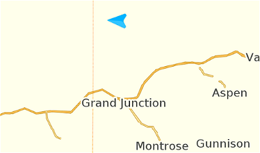
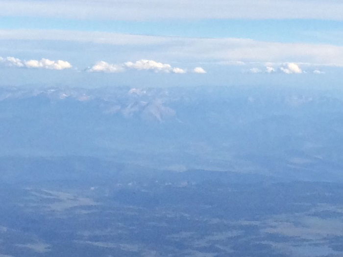
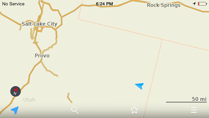
Most recently I used Maps.Me on my United Q400 flight in first class from Denver to Salt Lake City. We were flying over the Rocky Mountains where I have done extensive mountaineering and the views were spectacular. But the view from the ground isn’t quite the same as from the air, so I’m still not great at identifying peaks while flying over them. Knowing that I’m over Grand Junction and looking south can improve my guesses considerably.
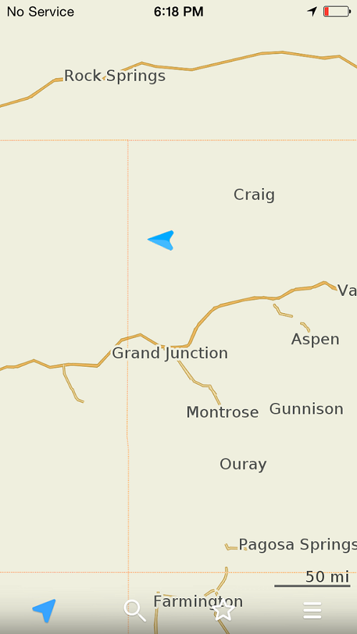
This helped me to identify (what I think was) the Sneffles Range off in the distance. Mt. Sneffles is one of the Colorado 14,000 foot peaks and where I had my mountaineering accident last fall.
Of course, I don’t always practice what I preach, so shortly after I took that screen capture we crossed the Utah state line and I was left with this.
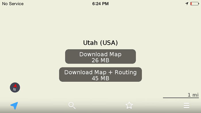
But like I say, even the basemap is still better than what you’ll get from Google maps. It was sufficient to know how much time was left in the flight. And besides, my battery was almost dead anyway.
Wait, Can I Even Use a GPS On A Plane?
I’m quite confident that if you ask a flight attendant this question, the answer will be no. Frankly, I have no idea what the harm in using one would be and I’m an electrical engineer. A GPS unit just receives and processes signals; it doesn’t actually transmit anything. Sure, they’ve got an oscillator in them for timing, but what doesn’t these days? Heck, your phone is probably running its GPS too — Facebook or some app always seems to want to know where I’m at. Then again, the terms of what you can and can’t do on an airplane aren’t always governed by logic, so if you use a GPS, I suggest not flaunting it.
One thing to keep in mind is that the hull of an aircraft essentially forms a Faraday cage. That means that the metal shell somewhat shields the interior from the RF signals emanating from the GPS satellites, the same signals that your GPS needs to figure out where you are. The net effect of this is that your GPS may have a hard time acquiring a lock, or there may be quite a bit of uncertainty in your position. I’ve found that holding the device up to the window helps, but regardless, we’re just trying to get the general location anyway so accuracy isn’t all that important.
How Much Does Maps.Me Cost?
Apparently Maps.Me is now open source software meaning that you can download it for free. That’s really cool, though I’m not sure how I feel about the fact that I invested $5 in a Pro version a couple of years ago. (Just kidding, I’m truly thrilled to see that it’s free for everyone. I just hope they can maintain the product going forward.)
It seems to be available for just about every platform, though of course I’ve only used it on the iPhone.
Conclusion
If you like to know where you’re at, where you’re headed, or where you’ve been, the flight map that’s part of the seatback IFE is awesome. But if you’re flying on a plane without such an AVOD system, you need to bring your own.
Maps.Me is an excellent offline mapping app that will show your position on a map even in the absence of a data connection. This can also be useful when you’re traveling abroad and don’t have an international dataplan. Given the app is now free, it’s certainly worth trying out.
What offline mapping app do you use? Have you ever been told not to use your GPS on a plane?


Two comments:
Switching your iPhone into airplane mode -- as you are required to do once the door closes, disables the GPS chip. I agree that may not be necessary to disable GPS, but that happens.
If your GPS is working, then you are not in airplane mode.
Pocket Earth is another excellent app for downloadable maps. Excellent detail at all resolutions. Displays railroad tracks for those of us interested in trains.
I always carry a Garmin Nuvi with me if I'm renting a car. Old school, but I've not found a mobile app which works as well. On occasion I've whipped it out (and the Nuvi too) on a plane and everything works fine. It was fun to ask it to calculate the route and watch it complain that I was over the speed limit @ 500mph. Once you set it to Pedestrian/Walking mode it actually...
I always carry a Garmin Nuvi with me if I'm renting a car. Old school, but I've not found a mobile app which works as well. On occasion I've whipped it out (and the Nuvi too) on a plane and everything works fine. It was fun to ask it to calculate the route and watch it complain that I was over the speed limit @ 500mph. Once you set it to Pedestrian/Walking mode it actually behaves properly and will show a correct ETA and other stats.
On the phone side, I'm on Verizon, so it's HERE maps being used offline when roaming. It's not a matter of being cheap as much as being able to afford it -- I don't think even Trump can afford Verizon's ridiculous roaming rates. I'm seriously considering T-Mobile, just very leery of their US coverage.
I think AA says in their inflight magazine not to use a GPS so I don't on AA. I had a Tom Tom on an AF flight from FCO to CDG at a window seat and it worked fine without having to hold it against the window. It was neat to see all the roads and rivers below mirrored on the screen with the town names and road names. Speed was like 500 miles per hour so it kept warning me when we were on a "road" what the speed limit was for the road.
For our folks out there, try CityMaps2Go! It's free on the App Store and pretty reliable
Mike (the first) -- I didn't realize that there was a way to get the speed. Will try that next time.
Mike -- Good point. On this flight, I wasn't in airplane mode because we were flying at 24,000 feet. I was still able to send and receive text messages. (Yeah, yeah, I know....)
Hermann -- Maps.Me has a lot more details than are shown in my lousy screen captures. I was zoomed way out to get the general idea of where I was at while in the air. Zooming in such that you can see every intersection isn't that helpful while flying at 24,000.
I've never used Here so can't compare. But I'll check them out sometime because it sounds like a good product.
Tom --
Agree, Google maps has some offline capabilities. But calling it a poor man's version of Maps.Me is a bit funny considering that Maps.Me is now FREE.
Two comments:
You can do a poor man's version of this on google maps by loading the map at the zoom you want and trying to scroll across your expected route before you takeoff. For example if flying NYC-SFO, you would cross Detroit, Chicago and usually follow the I-80 or I-70 corridor. Google maps will save the map for a few days and this is good enough to pick out what city you are...
Two comments:
You can do a poor man's version of this on google maps by loading the map at the zoom you want and trying to scroll across your expected route before you takeoff. For example if flying NYC-SFO, you would cross Detroit, Chicago and usually follow the I-80 or I-70 corridor. Google maps will save the map for a few days and this is good enough to pick out what city you are flying over and things like that.
Agree about it being very hard to get a GPS signal on a plane. I generally hold my phone up to the window for a few minutes and try switching positions and it generally will connect to the GPS at least briefly.
I'm also a fan of Maps.Me, and have been using it for 2+ years. My only concern is that, on my Moto / Android phone at least, it sometimes seems to forget to update and will show me the location I was at an hour ago.
Recently I realized that this may be due to the phone's GPS not updating, as evidenced by the "GPS Test" showing no location. When I let GPS Test...
I'm also a fan of Maps.Me, and have been using it for 2+ years. My only concern is that, on my Moto / Android phone at least, it sometimes seems to forget to update and will show me the location I was at an hour ago.
Recently I realized that this may be due to the phone's GPS not updating, as evidenced by the "GPS Test" showing no location. When I let GPS Test get a fix, then Maps.Me shows the correct location.
I also use Google Maps sometimes. It permits you to download several maps sections, but each one must be pretty small...useless for viewing during a flight.
fog or world!
Also using Here maps, great tool. Compared to you screenshots, Here maps also has some more details. Don´t know if this applies to iOS and Android as well, but on Windows Phone, downloaded Here maps also are accessible by other apps, e.g. my GPS tracker app that also shows altitude above ground (the Here app doesn´t do that, but I guess you shouldn´t need that when driving).
For those recommending HERE maps: enjoy it while you can, HERE was just bought from Nokia by a consortium consisting of Audi, BMW and Mercedes-Benz to use in their car's navigation systems. I really question whether we'll see the mobile product continue to be updated.
Why do you not put your phone in Airplane mode when you're flying? You're killing the battery by having it constantly search for a signal the entire flight.
In 2005 I owned a Garmin Emaps which I took on a flight to Alaska. This was my first hand held GPS, primitive by today's technology models, but way cool then.
I sat at a window, held it against the window panel, randomly tried it out and it was able to connect. ( it needed 4 satellites to know where it was!)
The screen wasn't even B&W, but instead that fuzzy gray LCD...
In 2005 I owned a Garmin Emaps which I took on a flight to Alaska. This was my first hand held GPS, primitive by today's technology models, but way cool then.
I sat at a window, held it against the window panel, randomly tried it out and it was able to connect. ( it needed 4 satellites to know where it was!)
The screen wasn't even B&W, but instead that fuzzy gray LCD look.
Flying over Oregon the ground speed measured something like 523 MPH, and showed the altitude as 33,200 ft. ...it never showed an exact city below as I guess the speed of the plane was more than it could do to locate the correct town, but it knew we were over a particular state.
The FA's never saw me using it so no confrontation about using it in flight.
I've never tried an in flight GPS since, still own this early pocket map, but now exclusively rely on Google maps on Android which I have used throughout Europe , Canada, the Caribbean and the U.S.
I'm a T-mobile customer so using data is not a problem away from the U.S.
Thanks for the heads up about an offline alternative!
@Travis,
You can download the maps for where you are "going" to be. In the case of your friend, he should have looked using Google Maps the area he was going to be visiting and select - Save Offline Map - or you can type "OK maps" in the search bar. Regardless of your data connections you will still be able to get access.
Hope this helps.
https://support.google.com/gmm/answer/3273567?hl=en
I also use Here maps by Nokia. Also includes gps navigation which is incredibly useful and is grouped by countries rather than states.
It is horrible to click hundredstimes "download"
I've used maps.me to as a primary means of navigation for driving a car from London to Mongolia.
Just out of curiosity when you use it in the air like that and "tap" on the blue arrow(your location) it gives your speed, what did your speed indicate?
I remember trying maps.me on a prop plane from WIL airport in Nairobi to Massai Mara and it displayed the ground speed when I tapped on the blue arrow.
I am a student pilot so mine will be very aviation based. Anyway, I use the XGPS160, which is made for use up to 60,000ft. It works everywhere (including Russia) as long as it has a satellite connection. It connects to your phone using bluetooth. I recommend either having a window seat, or connecting it in the terminal before boarding, because you can't if you are in the middle or aisle seats. (Even at the...
I am a student pilot so mine will be very aviation based. Anyway, I use the XGPS160, which is made for use up to 60,000ft. It works everywhere (including Russia) as long as it has a satellite connection. It connects to your phone using bluetooth. I recommend either having a window seat, or connecting it in the terminal before boarding, because you can't if you are in the middle or aisle seats. (Even at the window seat, you have to hold it against the window to get a signal, but they you should be good.) For my map software I went the cheap route and got fltplan mobile from the app store (run by flightplan.com but no account is necessary.) it comes with all the aviation maps for the US, Canada and parts of the Caribbean as well as BASIC maps of the US/ rest of world. just don't zoom into much, it will get blurry, and does not show you any more detail.
I was able to receive GPS on a recent flight from ZRH to FCO. I had no idea this was possible...it was pretty cool.
Or just use Nokia HERE maps which has offline packs and is far superior to maps.me
I've never been able to get my GPS work while flying. I have used iPhones and Androids, but there's no difference, i never get the signal no matter how many times i try. What's the secret? I mainly fly inside Europe, maybe in the US is different?